OUR SYSTEMS
DJI INSPIRE 2/X5S/ALTUM
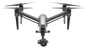
The ideal drone for working in Scottish conditions A dual battery system prolongs the flight time to a maximum of 27 minutes (with an X4S), while self-heating technology allows it to fly even in low temperatures. Provides a stable platform for aerial imagery capture in strong and gusty winds.
We are currently using a Zenmuse X5S sensor to capture 4K video and 20.8 MP stills in RGB. For multispecteral imagery capture the Inspire 2 can be mounted with the Micasense Altum. The Altum integrates a radiometric thermal camera with five high-resolution narrow bands, producing advanced thermal, multispectral and high-resolution imagery in one flight for advanced analytics.
DJI Phantom 4RTK + D-RTK 2
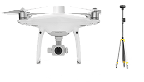
The Phantom 4 RTK was designed by looking at the requirements from the drone mapping and surveying market and building exactly what they wished for – a compact drone solution with a high resolution camera and the ability to capture centimeter-accurate RTK data. A new RTK module is integrated directly into the Phantom 4 RTK, providing real-time, centimeter-level positioning data for improved absolute accuracy on image metadata. The on board sensor is a 1″ CMOS sensor capturing images at 20 MP and video at 4K. The image quality in enhanced by the mechanical shutter which means the drone can move while taking pictures without the risk of rolling shutter blur. Using this drone a ground sample distance of 2.74 cm at 100m flight altitude can be achieved.
DJI Mavic Pro
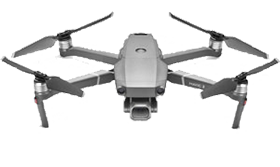
This ultra compact drone is ideal for work in remote locations. It feature a 12 MP 1/2.3 CMOS sensor which can take JPEG and RAW simultaneously and captures video at 4K at 30fps.